- Tree Cover (%)
- Pervious Cover Beneath Tree Canopy (%; representing land cover under tree cover)
Impervious Cover Beneath Tree Canopy (%; representing land cover under tree cover)
Evergreen Shrub (%; a percent of a percent, representing how much shrub cover is evergreen)
Impervious Cover (%)- Directly Connected Impervious Cover (%; a percent of a percent, representing a feature of impervious cover)
Herbaceous Cover (%)
Soil Cover (%)
Water Cover (%) - Pervious Cover Beneath Tree Canopy (%; representing land cover under tree cover)
Where do I get land cover information for my project?
You may be able to gather all of this information from local government, field-based surveys, or other sources. The following information is provided as guidelines for obtaining necessary data with minimal field or GIS work, based on common practices for modeling watershed area projects.
For Directly Connected Impervious Cover, please see this forum post about it: viewtopic.php?f=35&t=1233
Specifically, see the answer to "Can you suggest a good way to determine DCIA?"
For Evergreen Tree and Evergreen Shrub cover, various surveys can be performed to estimate this. These values indicate how much of total Tree and total Shrub cover have leafs year-round.
One way to get this information is: download Land Cover data (e.g. from http://nationalmap.gov), clip it to the extent of your project area, and then use its updated attribute table to estimate the percentage of Tree/Shrub Cover that is Evergreen Tree/Shrub % using the formula: Evergreen %=(evergreen/(evergreen+deciduous))*100
- For example, if Evergreen count is 200 and Deciduous count is 600: Evergreen Tree/Shrub % is (200/(200+600))*100=25%
You'll need your project area delineated (either manually or pre-processed from local government or other GIS data source) and in the Geographic Coordinate System of i-Tree Canopy/Google Maps: WGS 1984.
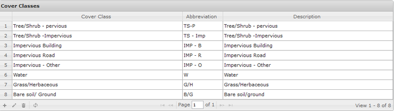
You'll also need i-Tree Canopy cover classes to be formatted to inform inputs for i-Tree Hydro. In the i-Tree Archives, under Hydro, we provide an 8 cover class file for this purpose.
- Here's an image of what the 8 cover classes looks like: https://static.itreetools.org/media/ima ... th-800.png
You can download that file from this link, and load it into i-Tree Canopy in Step 2: https://www.itreetools.org/documents/50 ... mple1_long
- Add Tree/Shrub - Impervious and Tree/Shrub - Pervious together to get Tree Cover. You can split this in half or some other division to account for part of this cover type representing shrub cover.
- For example, T/S-IC=20% and T/S-PC=10%, and then of total T/S cover users may estimate 60% were Trees and 40% were shrubs (or other distributions may be substituted), so in i-Tree Hydro: total Tree Cover is (20%+10%)*0.60=18% and total Shrub Cover is (20%+10%)*0.40=12%
- Determine how much Tree - Impervious and Tree - Pervious represent as fractions of Tree Cover respectively.
- For example, Tree-pervious/Total Tree Cover multiplied by 100 gives you the percent Pervious Cover beneath Tree Canopy: (10%/30%)*100=33.3% Pervious Cover beneath Tree Canopy).
- Add Impervious Building, Impervious Road, and Impervious Other together to get total Impervious Cover.
- Remaining cover classes translate directly into i-Tree Hydro: Bare ground/soil = Soil Cover; Water = Water Cover; etc.